Los Glaciares National Park is Argentina's largest protected area and the most iconic adventure destination in Patagonia. With 726,927 hectares encompassing 48 major glaciers, over 100 minor ones and a 370 km north-to-south span, it offers everything from accessible boardwalks facing Perito Moreno Glacier to multi-day wilderness traverses, boat tours between icebergs, fly fishing on glacial lakes and horseback rides to century-old estancias.
Trekking in Los Glaciares National Park
Los Glaciares National Park, declared a UNESCO World Heritage Site in 1981, is the largest national park in Argentina’s protected areas system. Covering 726,927 hectares, stretching 370 km from north to south with an average width of 35 km, it is home to 48 major glaciers and more than 100 smaller glaciers flowing from the Southern Patagonian Ice Field — the world’s largest freshwater reserve after Antarctica and Greenland. Among its most famous glaciers are Perito Moreno (254 km², as large as the City of Buenos Aires), Viedma (975 km², the largest glacier in Argentina and the second largest in South America), Upsala, and Spegazzini.
One Park, Two Worlds
The park is divided into two very distinct sectors. The southern sector, based in El Calafate, concentrates the great glaciers of Lake Argentino: Perito Moreno, Upsala, Spegazzini, Viedma, and Onelli. The northern sector, based in El Chaltén, is the kingdom of trekking, climbing, and Mount Fitz Roy (3,405 m) — a sacred peak for the Tehuelche people, whose name Chaltén means “smoking mountain.” Between both towns lies 200 km of paved road along the legendary National Route 40.
Climate and Best Season
The climate is temperate, with an annual average temperature of 7.5°C. Winters average 0.6°C, while summers average 13.4°C. The defining factor is not the cold but the Patagonian wind, which can change conditions within minutes at any time of year. High season runs from November to March: long days, open trails, and better weather stability. During winter season (May–September), trails remain open but registration at the Park Information Center is mandatory before hiking and camping.
Flora: Three Environments, Three Worlds
The park protects three clearly differentiated ecosystems:
Patagonian Andean Forest — Between lake level and 1,000 m, Nothofagus species dominate: lenga beech (the most abundant, turning deep red in autumn), ñire beech (adapted to extreme conditions and flooded soils), and guindo or Magellanic coihue (evergreen and moisture-dependent). Also notable are the notro tree (Embothrium coccineum) with scarlet-red flowers, the calafate bush (Berberis microphylla) with blue berries — a gastronomic symbol of the region — and the Guaitecas cypress (Pilgerodendron uviferum).
Patagonian Steppe — In the eastern sector, hard grasses (coirón), thorny shrubs (calafate, neneo), and during spring fragrant flowers such as oxalis, verbenas, and adesmias dominate the landscape.
High Mountain — Above 1,000 m, steep terrain hosts small resistant and colorful plants adapted to extreme wind, cold, and snow conditions. This ecosystem is home to Andiperla willinki, a tiny insect unique in the world that permanently inhabits glacier ice.
Fauna: Iconic and Protected Species
Andean Condor (Vultur gryphus) — With a wingspan of 3 meters, it glides effortlessly using thermal currents and can travel more than 200 km in a day. Frequently seen above Fitz Roy.
Huemul Deer (Hippocamelus bisulcus) — Endangered native deer declared a National Natural Monument in 1996. The park protects the southernmost Argentine population through annual monitoring and conservation programs.
Puma (Puma concolor) — Patagonia’s top predator. If encountered: shout, raise your arms, do not run, and never turn your back.
⚠️ Dangerous species — Yellow Jacket Wasp (Vespula germanica): an introduced exotic wasp capable of stinging multiple times. Serious risk for allergic people. Keep tents closed, inspect clothes and shoes, and never leave food exposed.
Walkways and Accessibility System
The walkway and viewpoint system facing Perito Moreno Glacier is one of Patagonia’s most valued tourism infrastructures. It allows visitors to admire the glacier wall — approximately 70 meters high — from multiple angles and elevations. Lower levels are accessible for visitors with reduced mobility.
El Chaltén Trails: Northern Sector
All trails start directly from town and do not require guides or permits, although registration at the Visitor Center is mandatory:
Laguna de los Tres — 20 km round trip, 800 m elevation gain. Direct view of Fitz Roy (3,405 m).
Laguna Torre — 18 km round trip, 5–6 hours. Ends facing Cerro Torre (3,102 m) with floating icebergs in the lagoon.
Condors and Eagles Viewpoint — 1 hour. Ideal for families and beginners.
Loma del Pliegue Tumbado — 18 km. Full panoramic views of the northern sector.
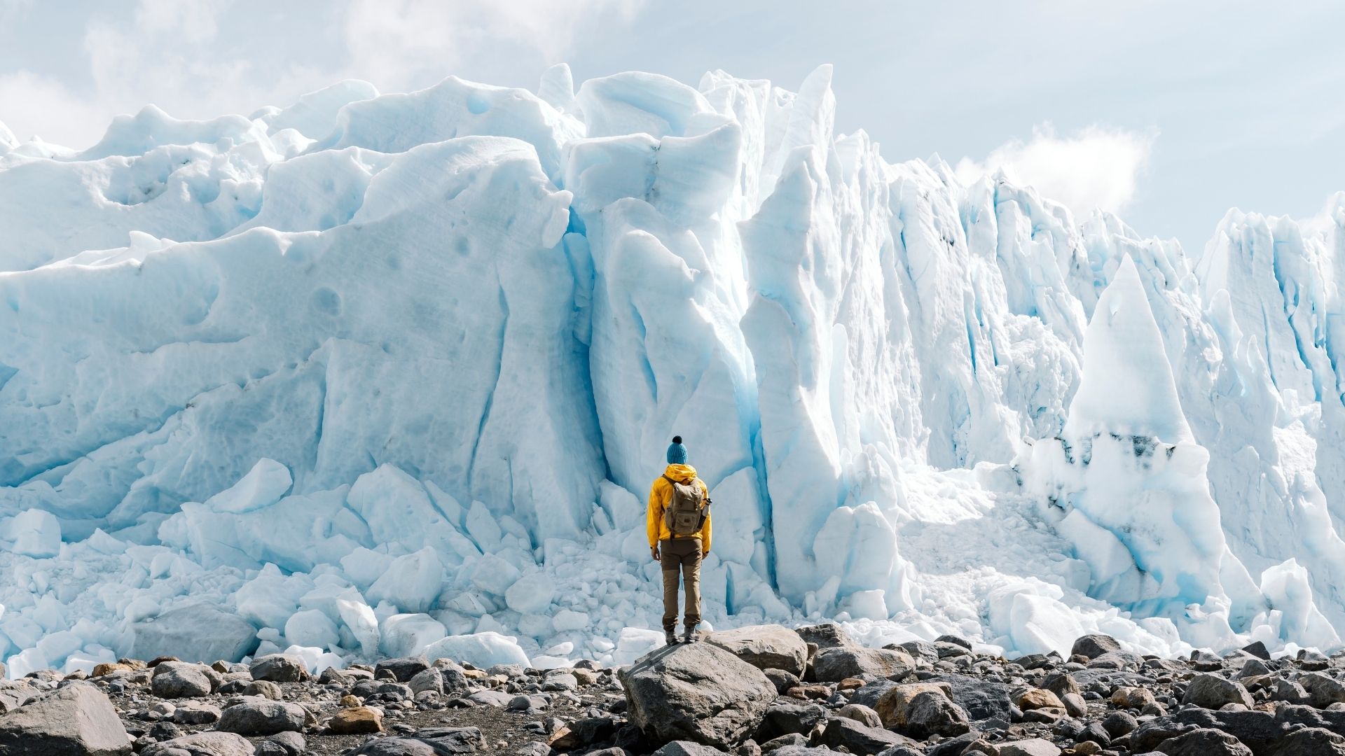
Hiking on Perito Moreno Glacier
Excursions on the glacier allow visitors to walk with crampons on living ice:
Minitrekking — 1.5 hours on the glacier. Suitable for almost anyone without prior experience.
Big Ice — 4 hours on the glacier with greater difficulty and deeper ice sectors.
Both include catamaran transfer and certified guides.
Glacier Navigation
From Punta Bandera (50 km from El Calafate), catamarans depart to explore Lake Argentino:
Upsala Glacier — the largest glacier in the park.
Spegazzini Glacier — the glacier with the highest ice wall (135 m), accessible through the "Glaciers Bay" navigation route, which also includes Heim and Peineta glaciers.
Onelli Lake — filled with icebergs detached from three glaciers; accessible via an 800 m trail from the dock.
Viedma Glacier Navigation — departing from Puerto Bahía Túnel, in the northern sector.
There is also navigation to the Perito Moreno Glacier from the Brazo Rico shoreline, offering a frontal perspective of the glacier wall.
Horseback Riding
Guided horseback riding excursions authorized by the park are a historic way to explore the territory:
Estancia Alice (El Galpón) — sheep herding and shearing demonstrations + 21 km horseback ride to Perito Moreno Glacier.
Lago Roca — 1-day and 2-day horseback expeditions with overnight stays near the Chilean border.
Estancia Alta Vista (33 km from El Calafate), Nibepo Aike (60 km), and Helsingfors (150 km, on Lake Viedma) offer estancia experiences with trekking, horseback riding, 4x4 tours, and fishing.
Sport Fishing
Fishing is a regulated activity that requires a valid official permit. Species include: rainbow trout, brown trout, sea-run brown trout, and landlocked Atlantic salmon (Sebago salmon).
Authorized fishing waters include Lake Argentino, Lake Roca, Lake Anita, Lake Viedma, and Río de las Vueltas (El Chaltén sector). Sea-run brown trout and steelhead fishing take place at Estancia Güer Aike (Truchaike), located 270 km away near Río Gallegos.
Fishing season: November to April.
Campsites and Service Areas
Southern Sector
Camping Lago Roca — organized campsite with services (Lago Roca Ranger Station).
El Huala — free campsite at Lago Roca.
Río Mitre Picnic Area — on the road to Perito Moreno Glacier.
Northern Sector (El Chaltén)
Río Blanco Base Camp — base camp for Fitz Roy ascents.
Cerro Torre Base Camp — located at the end of the Laguna Torre trail.
Piedra del Fraile Campsite & Refuge — Río Eléctrico sector, with mountain refuge services.
Several authorized campsites are distributed along the main trekking routes.
Tourist services (hotels, restaurants, agencies, gear rental, and gas stations) are concentrated in El Calafate and El Chaltén. Daily buses depart from El Calafate to Perito Moreno Glacier, Lago Roca, and El Chaltén.
Basic Park Regulations
Pets are not allowed.
Using firewood from the forest is prohibited; visitors must bring their own firewood for authorized fire pits. In the northern sector, only camping stoves are allowed — wood fires are prohibited.
Drones are prohibited.
Fishing requires a valid official permit.
Camping is only allowed in authorized areas.
All garbage must be removed from the park.
Climbers must register at the Information Center before departure.
During winter (May–September), registration is mandatory for trails and campsites.
Do not damage or remove cultural resources (rock paintings, arrowheads).
Do not feed wildlife.
Emergencies: (02902) 497010 / VHF: RX:150.375 TX:155.395
How to Get There
El Calafate — airport with daily flights from Buenos Aires (3 hours). Base for the southern sector.
El Chaltén — located 213 km / 3 hours by bus from El Calafate via Route 40. Base for the northern sector.
There is no public transportation inside the park; access is by private vehicle, rental car, taxi/remis, or organized excursion.
Park administration: Av. del Libertador Gral. San Martín 1302, El Calafate. Tel: (02902) 491-005/545/788.
Did you enjoy this article?