Fitz Roy can be seen from the village, but you only truly know it up close, on foot. We'll show you how to reach Laguna de los Tres, what to look for along the way, and what it takes to go even higher.
Trekking to Fitz Roy: The Complete Guide to Experiencing It from El Chaltén
The first time I arrived at Fitz Roy, more than fifteen years ago, it was completely covered by clouds. I couldn’t see a single peak of the massif. The same thing happened to me that happens to most visitors: clouds almost always hide the summit of Fitz Roy. That’s why the Tehuelche people called it “Chaltén,” which in the Aonikenk language means “smoking mountain.” To them, the ever-present cloud looked like smoke rising from a volcano.
Back then, El Chaltén was still a small, sparsely populated village. We arrived around lunchtime. The town’s only gas station was closed, and we had to wait until after the afternoon break before continuing our journey.
Patagonian weather changes quickly, and that afternoon it changed for the better. By the time we set out for a walk, the sky had cleared. That was when I saw it for the first time: the entire Fitz Roy range, its granite spires sharply outlined against a clear blue sky, as if the morning clouds had only been a rehearsal.
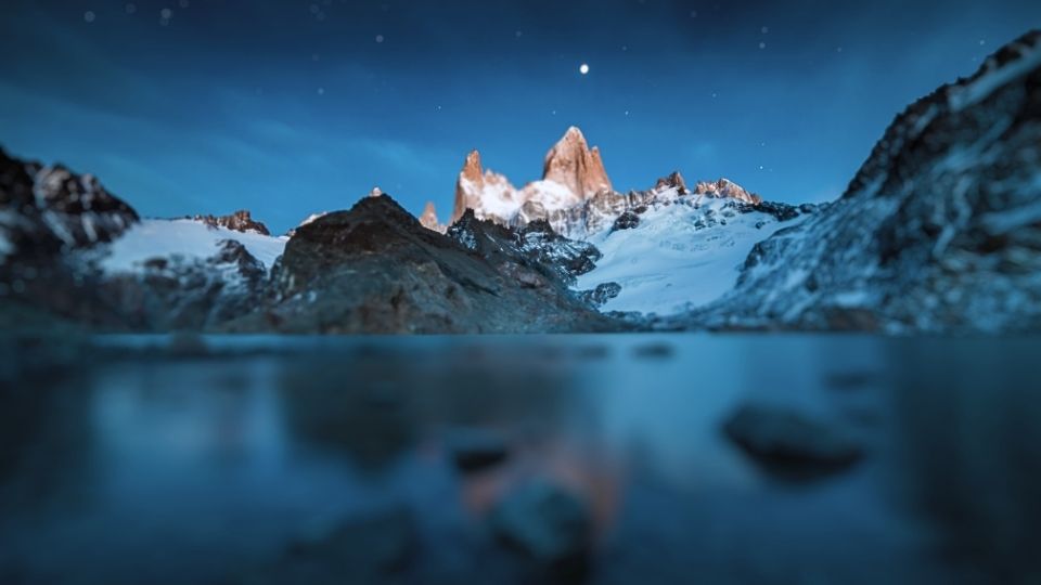
The Fitz Roy mountain (or Chaltén, 3,405 meters / 11,171 feet) dominates Los Glaciares National Park in El Chaltén, Argentine Patagonia. There’s an option for everyone: from easy viewpoints reached in 2 to 4 hours, such as Laguna Capri and Chorrillo del Salto, to the classic 8–10 hour trek to Laguna de los Tres—22 kilometers (13.7 miles) round trip, moderate to challenging difficulty—and even the detour to Laguna Sucia for those wanting to go a little farther. For the most experienced adventurers, there’s the summit itself, first climbed in 1952.
The Essentials
- All trails begin at the end of Avenida San Martín, a 15–20 minute walk from anywhere in El Chaltén.
- Short hikes to the most accessible viewpoints (Laguna Capri and Chorrillo del Salto) take between 2 and 4 hours.
- The full hike to Laguna de los Tres is approximately 22 kilometers (13.7 miles) round trip and takes between 8 and 10 hours.
- Difficulty ranges from easy to moderate for the viewpoints, moderate to challenging for Laguna de los Tres—mainly because of the final kilometer over a steep moraine with 400 meters (1,312 feet) of elevation gain—and technical for those attempting the summit.
- The best season is from mid-November to mid-March, with December and January offering the longest daylight hours.
- Since October 2024, access to Laguna de los Tres requires a Los Glaciares National Park entrance fee, payable online before departure. It’s advisable to check the current rate before traveling.
How to Reach Laguna de los Tres and the Fitz Roy Range
The trailhead is located at the end of Avenida San Martín, at the northern edge of El Chaltén, where the town ends and Los Glaciares National Park begins. It’s easily accessible on foot from any accommodation in town within 15 to 20 minutes, with no need for transportation or organized tours.
To reach El Chaltén from elsewhere, the nearest airport is in El Calafate, about 215 kilometers (134 miles) away—a three-hour drive or bus ride along National Route 40. Bus companies such as CalTur, Chaltén Travel, and Taqsa operate multiple daily services during the high season. Between December and March, there is also a direct bus service from Bariloche.
Tip: Start as early as possible, ideally before sunrise. It’s not just about the incredible morning light on Fitz Roy’s granite spires—the Patagonian wind tends to intensify after midday, especially on the final and most exposed section of the trail.
The Route: From Lenga Forest to Granite Walls
The hike to Laguna de los Tres can be divided into three distinct sections, each with its own scenery and challenges.
From Town into the Lenga Forest
The first kilometers are a pleasant uphill walk through lenga forests—a native Patagonian tree that turns brilliant shades of red and yellow in autumn. The trail passes near Laguna Capri, one of the best early viewpoints of Fitz Roy, often offering stunning reflections when the water is calm.
An interesting fact: the Fitz Roy range has a different color from the surrounding mountains. It is made of granite, an igneous rock that became exposed after erosion removed the sedimentary rocks that once covered it. That’s why Fitz Roy appears lighter and sharper than neighboring peaks.
The Final Kilometer: The Moraine That Tests Your Legs
After about two hours of relatively easy hiking, the trail changes dramatically. The final ascent to Laguna de los Tres begins: one kilometer of loose rocks on a glacial moraine, climbing approximately 400 meters (1,312 feet).
This is the section responsible for the trek’s “moderate-to-challenging” reputation. Take your time, use your hands for balance when necessary, and stop occasionally to catch your breath. The reward comes all at once: at the top of the moraine, Laguna de los Tres appears, with Fitz Roy towering directly behind it.
The lagoon’s name is no coincidence. It was given by the French expedition that completed the first ascent of Fitz Roy in 1952, referring to the three main peaks visible above the water: Fitz Roy itself and the Poincenot and Saint-Exupéry spires. Poincenot, in particular, commemorates a climber from that expedition who died while crossing a river during the journey.
Standing there, you understand why the Tehuelche believed Fitz Roy was a volcano—the mountain seems to breathe.
Laguna Sucia: The View Few People Visit
From the edge of Laguna de los Tres, a short ten-minute climb to the left leads to a viewpoint overlooking Laguna Sucia. Despite its name (“Dirty Lagoon”), the lake is anything but dirty. It is an intensely turquoise glacial lake fed by the Río Blanco Glacier, which cascades down from above in a series of waterfalls.
The name comes from the water’s turbidity. Like all glacial lakes, Laguna Sucia receives extremely fine sediment—often called “rock flour”—ground by the glacier and carried by meltwater. These suspended particles create the vivid turquoise color while also making the water appear cloudy.
The path to Laguna Sucia is not officially marked and crosses rocky terrain with limited signage, so it’s best attempted with good visibility and plenty of time.
For Those Looking for More: The Summit of Fitz Roy
Laguna de los Tres marks the end of the hiking trail, but not the end of the mountain. Above the moraine, Fitz Roy rises nearly another 2,300 meters (7,500 feet), culminating in a granite wall first climbed in 1952 by a French expedition led by Lionel Terray and Guido Magnone.
Today, reaching the summit remains a serious mountaineering objective. It involves multiple days, high camps such as Río Blanco and Paso Superior, bivouacs, and rare weather windows that often last less than 24 hours. The Franco-Argentina and Supercanaleta routes are among the most famous, both requiring certified mountain guides and significant experience in rock and ice climbing.
There’s another interesting connection: the logo of the outdoor clothing company Patagonia is based on the silhouette of Fitz Roy, inspired by founder Yvon Chouinard’s climb of the mountain in 1968.
Practical Information for the Fitz Roy Trek
Recommended Season: Mid-November to mid-March
What to Bring:
- Layered clothing
- Waterproof windbreaker
- Sunscreen
- Hat
- Plenty of water
- Food for the entire day
- Some cash
What Not to Bring:
- Footwear without ankle support
- 100% cotton clothing (it provides little insulation when wet)
Cell Phone Coverage:
- Very limited or nonexistent along most of the trail
For shorter outings, Laguna Capri and Chorrillo del Salto offer rewarding viewpoints within 2 to 4 hours. If you want to extend the adventure, Laguna Sucia adds about an extra hour. A summit attempt, however, is measured in days rather than hours.
How to Plan Your Visit to Fitz Roy
Independent Hiking (Most Popular Option)
The trail to Laguna de los Tres is well marked and does not require a guide. Visitors simply need to pay the entrance fee to Los Glaciares National Park and carry some backup cash, as card payments can occasionally fail.
Via Río Eléctrico
For those looking for a different route or a shorter approach, minibuses operate from El Chaltén to the Río Eléctrico bridge, where another access trail begins. Along the way, hikers can visit the Piedras Blancas Glacier viewpoint.
Guided Summit Climbs
If your goal is to climb Fitz Roy rather than simply admire it, specialized local operators organize 4–5 day expeditions with certified IFMGA mountain guides, including camp logistics and high-altitude bivouacs.
Where to Stay
Within El Chaltén, mountain lodges with direct views of the Fitz Roy range offer the most comfortable experience. For something more unique, Refugio Piedra del Fraile in the Río Eléctrico Valley and the lodge at Estancia Los Huemules near Cagliero Glacier provide memorable stays away from the busiest areas.
For those chasing sunrise over Fitz Roy, Campamento Poincenot—located inside the national park along the Laguna de los Tres trail—offers free camping.
Frequently Asked Questions
Is the Fitz Roy Trek Difficult?
The hike to Laguna de los Tres is considered moderate to challenging. The first 8 kilometers are relatively easy, but the final kilometer gains around 400 meters over loose rocks and requires a reasonable level of fitness.
Do You Need a Guide?
No. The trail is clearly marked and heavily traveled during the hiking season, so most visitors complete it independently.
How Long Does the Hike Take?
Typically between 8 and 10 hours round trip from El Chaltén, excluding time spent at the lagoon. Shorter viewpoint hikes can be completed in 2 to 4 hours.
Can Children Do the Trek?
Nearby viewpoints such as Laguna Capri and Chorrillo del Salto are family-friendly. The full trek to Laguna de los Tres is more demanding and should be evaluated based on each child’s age and fitness level.
Is There Cell Service on the Trail?
Little to none. It’s recommended to download an offline trail map before leaving El Chaltén, as reception disappears shortly after starting the hike.
What’s the Difference Between Laguna de los Tres and Laguna Sucia?
Laguna de los Tres is the official end point of the trail at the base of Fitz Roy. Laguna Sucia is a short detour of about ten minutes from there, known for its intense turquoise color created by suspended glacial sediment.
After a day like this, El Chaltén has its own closing ritual: a traditional Patagonian barbecue or slow-roasted lamb, followed by a stop at one of the town’s famous chocolate shops.
One of the most spectacular views is at sunrise. Are you ready to experience it?
Did you enjoy this article?